 |
iSwitzerland Apps Collection
iWestAlps
Latest version:
2015-12-01 
|  |
|
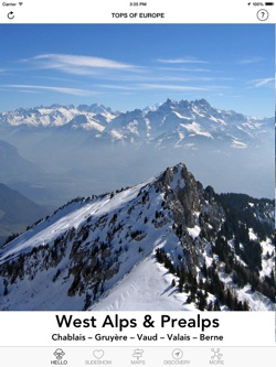
Stretching from France to Austria, the Alps are a scenic destination for winter sports and summer hikes. This app is focused on the Western Alps, from the French Chablais to the Bernese Alps, through the destinations in the Swiss cantons of Fribourg, Vaud, and Valais.
It's not an app made for mountaineers, it's made for hikers and skiers as well as people who just love to enjoy breathtaking panoramas while having a drink on a sunny terrace near the cable car top station.
A journey through the Prealps and Alps, in France, Switzerland, and Italy, with towns, villages, summits and other points of interest displayed on relief maps with highlighting of your current location. See what's around you and what is hidden behind the peaks surrounding you!
On ski slopes or hiking trails, see where you are precisely, with contour lines displaying the surrounding relief. No need for a connection, the GPS of your device does the job and shows you everything on embedded maps.
Featured areas:
Vaud Alps (Les Diablerets, Leysin, Villars-Gryon, Les Mosses...)
Fribourg Prealps (Gruyères, Moléson, Jaun, Charmey...)
Pays-d'Enhaut (Château-d'Oex, Rossinière, Rougemont...)
Saanenland (Saanen, Gstaad, Gsteig, Schönried...)
Simmental (Zweisimmen, Lenk...)
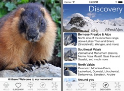
Bernese Alps (Grindelwald, Wengen, Jungfraujoch, Adelboden, Kandersteg...)
Chablais Alps (Abondance, Morgins, Avoriaz, Morzine, Champéry, Morgins...)
Southwest Valais (Verbier, Veysonnaz, La Tzoumaz, Les Marécottes, Champex...)
Southeast Valais (Zermatt, Saas Fee, Arosa, Zinal, Grimentz, Saas Grund...)
North Valais (Crans-Montana, Anzère, Ovronnaz, Leukerbad, Derborence, Sanetsch...) |
|
 |  |
|